How to See Old Images on Google Maps
Ad
Did you know that it is possible to go back in time? Well, let’s say that exactly what is said is not going back in time, but rather taking a “travel through time”. Many people are unaware, but it is possible to see old images on Google Maps.
Surely you have ever been curious to know what your city was like a few years ago, for example. Or even any other place in the world. Now this is possible thanks to old images on Google Maps, which allow us to relive the past.
It is something truly fantastic and even somewhat nostalgic. I confess that these days I went back in time and went to see what a house I lived in many years ago was like. As they say, “to remember is to live again”. These old photos on Google Maps really brought back a lot of pleasant memories.
Ad
If you also want to live this wonderful and unique experience, in this post I will teach you how to see old images on Google Maps in simple steps. So embark with me on this “trip to the past”!
Traveling in Time with Google Maps
I certainly must have piqued your at this very moment. It really looks incredible, but it’s simpler than you might think!
Ad
It’s no secret that Google Maps is one of the most popular navigation platforms in the world. However, few know that the platform can also be used to “go back in time”.
All of this is possible thanks to one of its most famous features, Street View. With it, we can somehow walk the streets, avenues, roads, get to know tourist attractions more closely and much more. And also using the “doll” feature we can access old images on Google Maps.
In case you’re wondering: But how could this be? The answer is very simple! Google Maps constantly updates available images, but it manages to keep some old images in the system. That’s why we can access these images so easily!
Accessing Historical Images on Google Maps: A Step-by-Step Guide
Now that you have an idea of how it works, let’s get to the point! Check out the complete step below to access old images on Google Maps:
- Open Google Maps on your mobile device. If it is not installed, go to the app store and download it.
- After opening the app, write the desired location or even a specific address in the search bar.
- Then, click on “Layers” at the top of the screen.
- Select the “Street View” option, and then click the “X” to exit.
- Now, click on any blue line or specific point you want to see.
- Then tap the “See more dates” link at the bottom of the screen. Remembering that not all places on Google Maps have this link
- Select an image from the carousel.
Ready. Now just enjoy your trip!
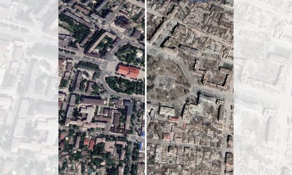
The Importance of Image Storage in Google Maps: A Window into the Past
The Importance of Image Storage in Google Maps: A Window into the Past
Storing old images on Google Maps plays a very significant role as it offers a window into the past, which allows users to learn, explore, and most importantly. We appreciate up close the changes that have occurred over time on our planet.
Furthermore, it is a source of visual information, as this historical record can be used to monitor the development of natural urban and rural areas.
This rich source of visual information plays a key role in many areas, from urban planning to historical preservation and education. Even urban authorities and city planners use this resource to better understand how cities have evolved over time. It’s really fantastic to be able to access all of this so easily!
Use Cases and Practical Applications: How Old Images Can Be Useful
As we saw above, this “window to the past” can be very useful in several ways. Some of them may be:
For historical purposes: These can be used to document changes in the landscape over the years. For example, thanks to old images it is possible to see how a city grew or how a natural disaster affected a certain area.
For research purposes:Also allows you to research environmental changes, such as deforestation. For example, the images can be used to study how a river changed course or how a forest was deforested.
For recreational purposes: Of course we couldn’t fail to mention this utility, as this Google Maps feature allows you to explore places that no longer exist. This way you can visualize, for example, what your home was like before you were born.
Limitations and Ethical Considerations: Exploring the Past Responsibly
Exploring the past using old Google Maps images is truly a unique experience, but at the same time it has certain limitations. See some of them:
Image quality: Some images are not always of high quality.
Availability of images: Old images, as previously mentioned, are not available for all geographic areas and may vary from one region to another.
Temporal precision: Even though Google Maps provides images from different years, the temporal precision of the images may not be sufficient for more detailed historical studies.
Regarding ethical considerations, we must emphasize that this activity must always be carried out respecting people’s privacy, obtaining consent when necessary and using images responsibly and accurately. Likewise, copyright must be respected and always attribute sources when sharing or publishing information based on these images.
Conclusion
Travel going back in time with old Google Maps images is a fascinating experience. Follow the step-by-step instructions presented in today’s post and explore the past of locations around the world. Enjoy this unique experience and start your trip right now!
 The Best Video and Photo Editing Applications
Ad Can you imagine creating those spectacular videos or posting incredible photos that even your favorite influencers […]
More Best Apps for Editing Photos on Your Cell Phone
Ad Are you looking for how to edit your photos and don’t even know where to start? […]
More Exploring the Possibilities of Scanner via Cell Phone: Tips and Tricks
Ad If you still doubt that with your smartphone in hand it is possible to do a […]
More